


38 2022 08 01 Boucle Bourg D'Oisans

OLYMP42
User
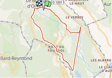

Length
8.8 km

Max alt
749 m

Uphill gradient
84 m
Km-Effort
9.9 km

Min alt
716 m

Downhill gradient
85 m
Boucle
Yes
Creation date :
2022-08-01 07:42:58.28
Updated on :
2022-08-01 14:19:13.865
2h06
Difficulty : Easy

FREE GPS app for hiking
 SityTrail
IGN / Geographical institutes
SityTrail Plus
The world is yours!
About
Trail Walking of 8.8 km to be discovered at Auvergne-Rhône-Alpes, Isère, Le Bourg-d'Oisans. This trail is proposed by OLYMP42.
Positioning
Country:
France
Region :
Auvergne-Rhône-Alpes
Department/Province :
Isère
Municipality :
Le Bourg-d'Oisans
Location:
Unknown
Start:(Dec)
Start:(UTM)
266496 ; 4992989 (32T) N.
Comments